Observatory's livrables
Last update: 15 March 2024
Within the framework of the creation of the Indian Ocean Observatory of Agriculture (OA-OI), a work of historical, political and economic analysis of the countries concerned is necessary.
This knowledge of the current context and the issues to be taken up will notably enable us to develop a tool adapted to the needs identified and useful in the accompaniment of the transformations to be carried out.
This first work of the situation allows us to :
- Understand how the agriculture of the five countries of the southwestern Indian Ocean region has taken shape;
- Identify the current structure of the agricultural world as well as the place and roles of agriculture in these different national economies;
- Characterize the farms in their diversity, based on an existing bibliography;
- Identify hypotheses on the difficulties encountered by farmers and other actors in the sector, and their needs.
Contents
Agriculture in Madagascar: key figures and challenges
Download the full documents (only in French ): L'agriculture à Madagascar: évolution, chiffres clés et défis (janvier 2023)
Download our 9 synthetic illustrations (only in French): marqueurs de l'agriculture à Madagascar (décembre 2023)
This fourth opus focuses on Madagascar, one of the three pilot areas we have been working on since March 2021. This summary, rich in information and lessons on agriculture in Madagascar, is based on numerous sources and bibliographical references. It was produced as part of the feasibility study for the Observatory of Agriculture in Madagascar project, between March 2021 and November 2022.
This document is structured in four parts:
1/ The first part describes the geographical, physical and climatic characterisation of the environment, Madagascar's demographic situation and development, and describes its
exceptional but threatened biodiversity ;
2/ The second part presents a few historical facts relating to agriculture and shows how agriculture in Madagascar has evolved over time ;
3/ The third part provides an overview of the agricultural sector today, outlining its importance to the national economy, describing the diversity of agriculture in Madagascar and the main components of agricultural production. This section also describes the organisation of the sector, highlighting the importance of family farming, and presenting some of the stakeholders involved in rural development, as well as the main agricultural policies currently being implemented.
4/ Finally, the fourth section identifies the main issues and challenges facing the agriculture, livestock and fisheries sector in Madagascar.
Agriculture in Mauritius: key figures and challenges
Download the full documents (only in French ):
- Synthèse sur l'agriculture à Maurice: chiffres clés et défis (mai 2021)
- L'agriculture à Maurice: évolution, chiffres clés et défis (mai 2021).
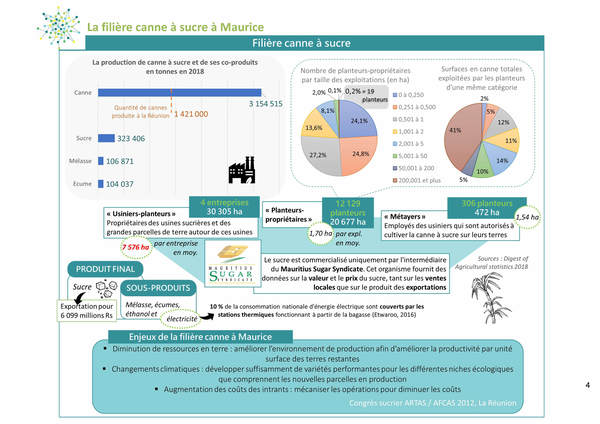
The third summary document focuses on Mauritius, a small island state in the Mascarene archipelago where sugarcane cultivation is still predominant, occupying three quarters of the Utilised Agricultural Area (UAA).
Mauritius, which covers an area of 1865 km², currently has a population of 1,221,663 (2020, source: populationdata.net).
As on Reunion Island, two seasons stand out. The summer season, from November to April, with hot temperatures (average temperature of 24.7°C) and high humidity. The winter season, from June to September, has cooler temperatures (average temperature of 20.4°C) and drier weather.
Sugar cane, introduced in 1639 from Java by the Netherlands, was initially used for the production of arrack (ancestor of rhum, a product resulting from the fermentation of the cane). Other crops such as "corn, sweet potato, rice, wheat, tobacco, indigo, vine, vegetables, pineapple and other fruits" were also introduced by the Netherlands and allowed to feed the island population. Agriculture was progressively structured around the cultivation of sugar cane with the appearance of large sugar plantations. "The farms of more than 42 ha occupy, in 1980, 64.4% of the surface harvested in sugar cane and those of more than 211 ha, 59.6% of this surface".
In 2014, the 18,260 family farming farms occupy 17% of the Mauritian territory and have an average area of 0.62 ha; the 90 non-family farms (capitalistic) with an average area of 594 ha, occupy 83% of the Mauritian territory. They mainly cultivate sugar cane; some of them are diversifying into food crops, meat, livestock, poultry, processed dairy products and animal feed.
Mauritian agriculture is still not very diversified. Sugar cane remains the main crop of Mauritius. It occupies 78% of the total agricultural area. As the productivity of this sector is under pressure, it must reinvent and diversify in order to find alternative markets to sugar production, which it has begun to do by developing the co-products of sugarcane such as molasses, dross, bagasse for energy recovery of this biomass. In 2018, 7,656 ha (or 13.7% of the total utilized agricultural area) were dedicated to food production; 656 ha to tea cultivation, a traditional Mauritian crop. In addition, 15 small, medium and large farms converted to organic farming between 2016 and 2019.
However, the food self-sufficiency of this small territory is not covered. There are problems of scarce or uncultivated land. The population of farmers is aging; young Mauritians do not see this sector as an innovative and promising one. Agriculture is exposed to difficult climatic constraints; the pressure on natural resources (soil and water) is strong. The challenges are huge. Among the issues identified, the need for training and innovation are very real and investments are required.
Agriculture in Reunion Island: key figures and challenges
Download the full documents (only in French ):
- Synthèse sur l'agriculture à La Réunion: chiffres clés et défis (mai 2021)
- L'agriculture à La Réunion : évolution, chiffres clés et défis (mai 2021)
This small French overseas department, also an overseas European region in the Indian Ocean, is located 9,200 km from mainland France. This geographical distance has a direct impact on trade with France and the standard of living on the island. The residents and the economy are thus strongly dependent on sea and air transport.
With an area of 2512 km², this volcanic island was born some three million years ago. The imposing reliefs of the island are the result of a hot spot at the origin of two volcanos : the « Piton des Neiges », inactive today and the « Piton de la Fournaise », one of the most active volcanos in the world.
The island is mainly under the influence of the winds coming from the northeast; the rainfall is contrasted, strong in the east because of the high reliefs; agroecological gradients are also observed according to the altitude.
An unfavorable topography, an important pressure on the land due to a galloping urbanization and the classification of 40% of the territory as a national park make that the extension of the agricultural surfaces between the coast and the highlands remains limited.
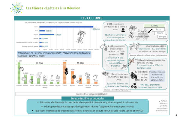
On the scale of the department, the total utilized agricultural area (UAA) amounts to approximately 42,000 ha, i.e., less than 17% of the total area of the department (source: AGRESTE, 2018), a ratio much lower than that observed in « France hexagonale ». The average UAA of a farm in Reunion is 6.1 ha; although it has almost doubled since 1989, it is still far below the surface area observed in « France hexagonale » (63 ha in 2016) (Source: INSEE).
Reunion's agriculture "is characterized by its family character, in the way that it is above all the family labor that is valued within a farm whose size remains modest. It is also dual, with so-called professional family farming and so-called social (informal) family farming, located in the highlands of the island."
Of the 6,900 farms listed, nearly 50% of them produce sugarcane. The sugar cane sector is thus the most important sector in terms of surface area, number of farms and turnover; it is organized around a single major actor, the manufacturer Tereos. Livestock occupies 28% of the UAA. This sector has been highly structured since 1975. The remaining UAA is dedicated to the cultivation of fruits and vegetables and more marginal traditional sectors such as aromatic, perfumed and medicinal plants (PAPAM), coffee or even vines and lentils in the cirque of Cilaos...
Finally, the challenges of agricultural development in Reunion are numerous. They concern the protection of agricultural land, the diversification of agricultural activities, especially for the sugarcane industry, an efficient governance of resources to move towards a circular economy...
Agriculture in Seychelles: key figures and challenges
Download the full documents (only in French ):
- Synthèse sur l'agriculture des Seychelles: chiffres clés et défis (septembre 2020)
- L'agriculture des Seychelles: évolution, chiffres clés et défis (septembre 2020)
This synthetic document introduces to the Seychelles, a small island state in the central west of the Indian Ocean, famous for its paradise beaches. The agriculture of Seychelles is confidential and the potential agricultural lands are not much exploited today. In addition, this study provides an overview of the history and the political and economic situation of the archipelago, as well as the evolution of this sector over time, a brief image of the sector today and the challenges that it faces today.
With 115 islands and islets, the country has a total area of 455 km², which ranks it as the smallest African state. Two groups of islands can be observed: the first main one, located in the northwest, because of its surface, the number of residents and the economic activities and in particular agricultural that it supports, is formed of granitic rocks. The second group, composed of sandy or coral islands, also called "outer islands", is located in the South-East; it presents more fertile soils, still little exploited agriculturally but with the greatest potential.
More than 87% of the Seychelles population lives on the largest island, Mahé, in the urban area of the capital, Victoria.
At the beginning of the 21st century, this small archipelago had lost 78% of its arable lands. Seychelles, then far from food self-sufficiency, imported 90% of the products consumed by locals and tourists and exported very few agricultural products. The traditional cash crops (coconut, cocoa, coffee...) were progressively left behind and gave way to agricultural production for local consumption (fruits and vegetables) and livestock. Today, the country is still dependent on imports for more than 70% of its needs.
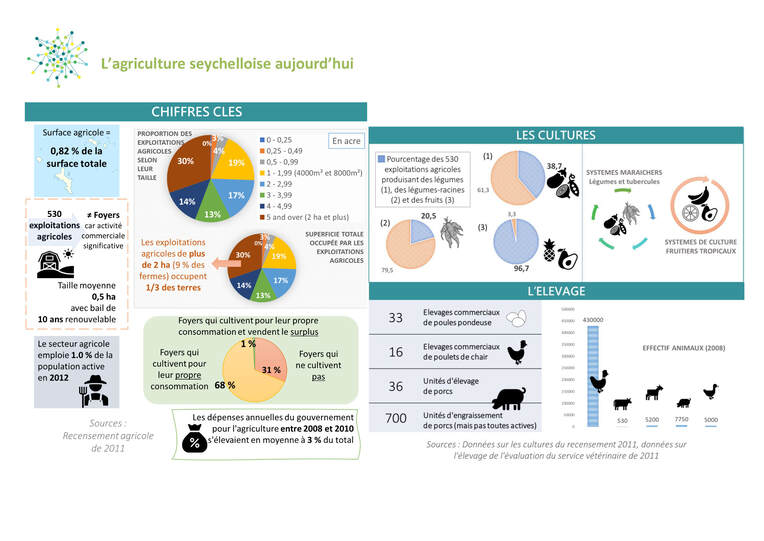
According to the 2011 census, Seychelles has 530 farms (declared as such), the big majority of which are engaged in commercial agriculture. Seychelles' farms are characterized by their small size and the majority of them are located on state-owned land. Many of the private lands have found a much higher profitability in tourism activities. The farmers are therefore renters of the State and the contract that binds them implies productivity requirements.
Seychelles now has 48 " big " farms of more than 2 ha covering 30% of the total cultivated area of the country. The most numerous farms (160) in Mahé, Praslin and La Digue have an area of between 0.4 and 0.8 ha. The smallest farms (less than 0,2 ha) cover 3% of the total area with 83 farms. The vast majority of farms (82%) are single plot farms.
Seychelles has "... another 6,000 households that farm, either for their own consumption or to sell the surplus to supplement the household income...".
The challenges facing this sector, which are numerous and of different kinds, all address the issue of food and nutritional security in the Seychelles and a reduction in dependence on agri-food imports. They concern the protection and sustainable use of agricultural resources (land and water), the diversification and productivity of the agricultural sectors, the sustainable management of aquaculture and fishing, the strengthening of the capacities of the actors concerned...
Last update: 15 March 2024


